Part 2. – The Investigation
“Imua e nā pokiʻi a inu i ka wai ʻawaʻawa, ʻaʻohe hope e hoʻi mai ai”
“Forward, my younger brothers, and drink of the bitter waters; there is no turning back.”
– attributed to Kamehameha I
Prologue
The Tangi Valley, 65km southwest of Kabul, runs from northwest to southeast. The fast-flowing Logar River winds through the valley floor, which is bounded by steeply rising ground and high mountains. Running alongside the river, the Tangi Road connects the Kabul-Kandahar highway and the city of Sayad Abad at the western end to the scattered villages and small towns in the area.
To the Pashtun people who live in the Tangi Valley, it is a place of apple orchards and groves of apricots, supported by an ancient irrigation system supplemented by mountain streams; famous for its literary culture, rural hospitality, and the prowess of its warriors.
To those fighting the war in Afghanistan in 2011, it is a vital corridor funneling weapons and men to those resisting the US-led coalition: the Taliban and their allies in the Haqqani Network. The Taliban and the Americans have been contesting control of the valley for months: by August 2011, the Taliban are gaining the upper hand.
The local Taliban commander is Qari Tahir. Recently put in charge of operations across the Tangi, with a history of ordering suicide bombings and improvised explosive devices, and with strong links to the Haqqani Network, he is on the American target list.
At 23.00 local time on August 5th, two helicopters land a platoon of Rangers, some 47 men strong, near a location thought to be hosting Tahir, near the village of Kamran Khel. By 23.30 the Americans have taken control of the compound, but not before a small group of men escapes.
US Apache helicopters engage a second group of armed men moving north of the compound, killing six. Rangers give pursuit to the original group, which they believe includes Tahir and which has headed northwest into the valley. By 01.35, this group has grown in numbers to some ten men.
The Rangers realise they are being drawn deeper into terrain that favours the Taliban. They halt their pursuit at the edge of one of the settlements, Spin Wersek.
Tahir is about to escape.
Commanders decide to deploy a unit of some 17 SEALs from Naval Special Warfare Development Group as an Immediate Reaction Force. They will land ahead of Tahir, cut off his escape, and capture or kill him.
Around 02.00, commanders add 5 supporting NSWDG troops to this force, along with 3 USAF Special Tactics airmen, 7 Afghan partner force troops, and an interpreter. The 33 passengers and 5 crew will go together in a single helicopter, a CH-47D Chinook. Its callsign: Extortion 17.
Tangi Valley, Maidan Wardak, Afghanistan.
August 6th, 2011. 2.00AM.
39 minutes before Extortion 17 is shot down.
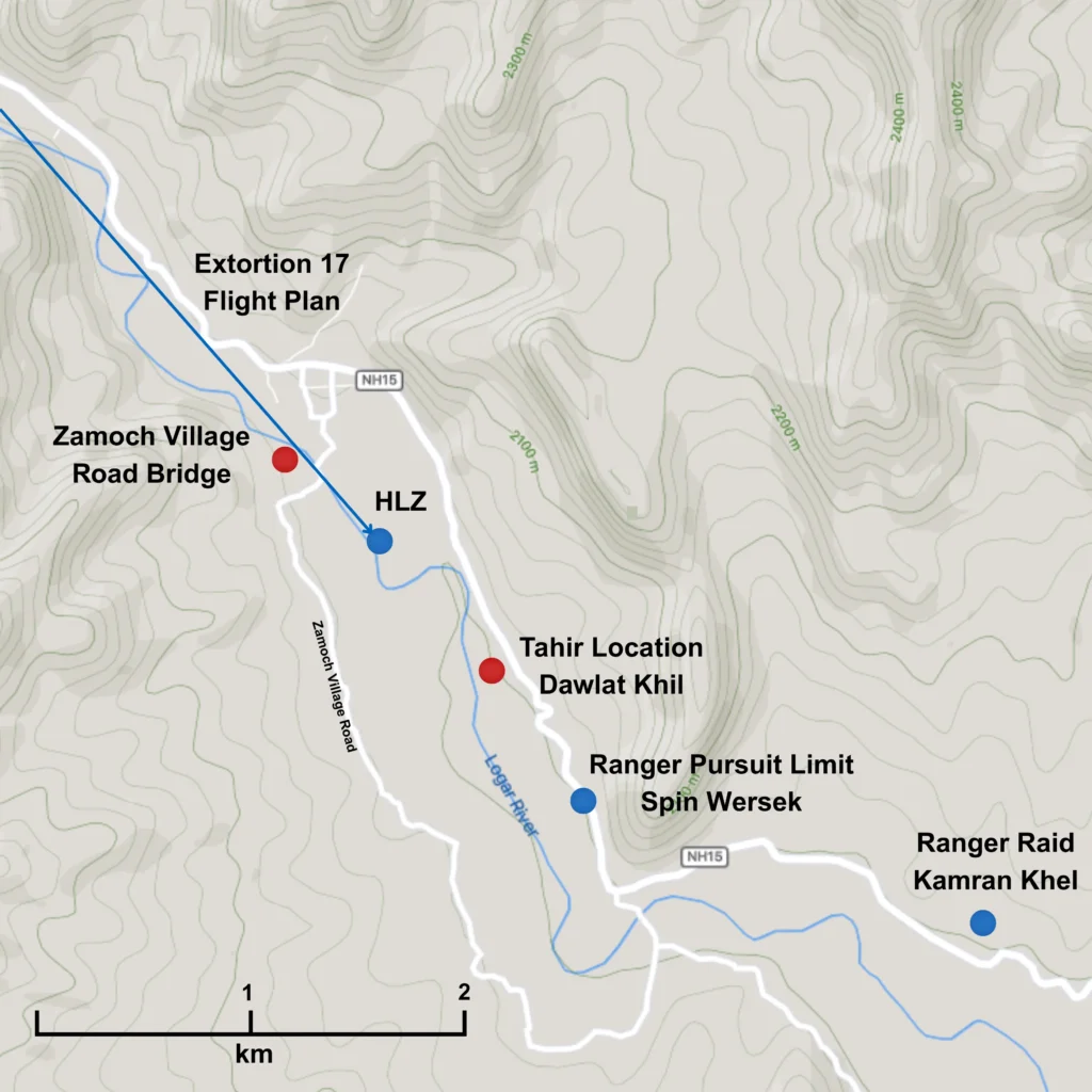
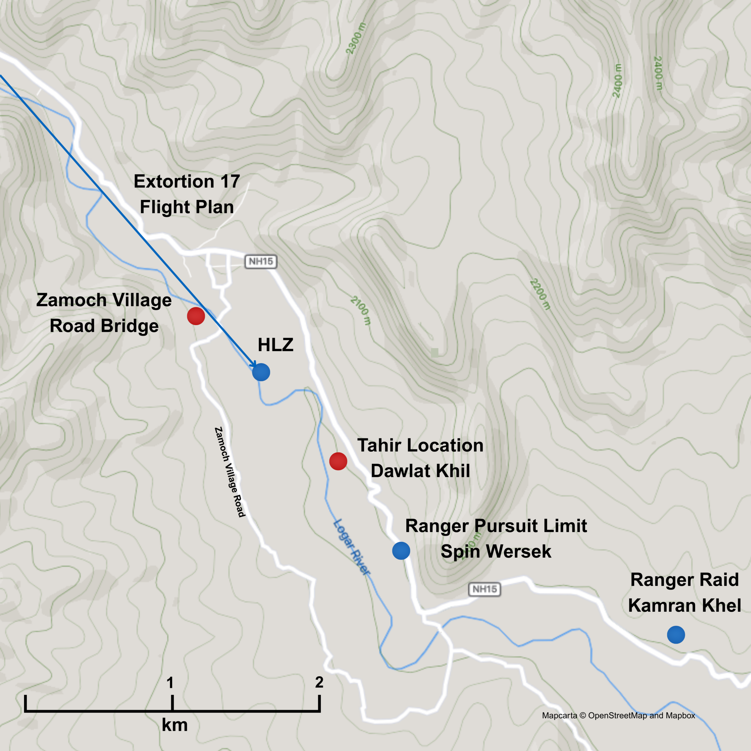
Fig. 1. Overview. Tahir escapes pursuit. After fleeing a raid by US Army Rangers in Kamran Khel, Tahir, the area’s Taliban leader, is now in Dawlat Khil, 3.3km along the road. US forces plan to land a helicopter carrying an interdiction force 800m north west of him: the intended helicopter landing zone (HLZ) is shown. Source: the Colt Report. Mapcarta © OpenStreetMap and Mapbox [Hi-Res]
Three questions. How did the Taliban know the helicopter was coming? How did they make the shot? Why were 38 men and a military dog all together in one helicopter?
This account brings together the physics, the terrain and the known capabilities of those fighting in the Tangi Valley that night, based on published sources, to offer an explanation beyond the simple claim, “it was a lucky shot”.
Let us go back to Tahir, the target of the Extortion 17 mission.
Tahir
Tahir is in trouble. He had not expected to spend his evening running for his life from the Americans.
The Taliban boss had nevertheless successfully evaded the Rangers, and headed northwest, moving 3.3km (~2 miles) up the valley through a narrow strip of land, several hundred metres wide, caught between the river to the west and rising ground to the east.
He and ten of his men are now in the village of Dawlat Khil, 1.3km southeast of a bridge carrying the Zamoch Village Road.
The bridge is held by another Taliban unit, who are based in the northwest of the valley.
The area between Tahir and the bridge is covered in orchards: good for concealment. Staying under the trees, he can avoid being spotted and attacked by American aircraft, join up with his allies and get away.
Tahir and his men are so close to safety, 1.3km from their allies: less than a mile.
The Web: Ayoubi and the Spider
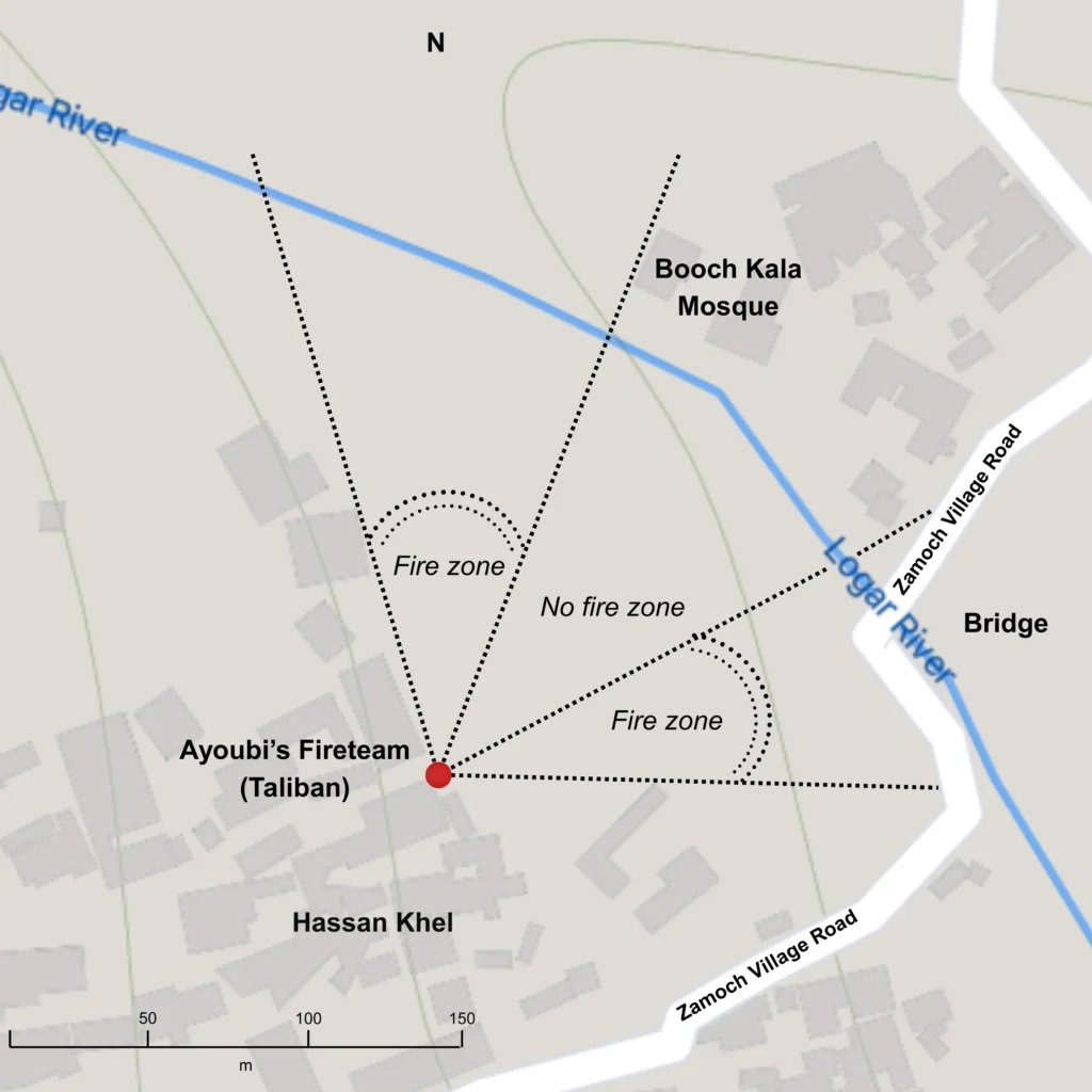
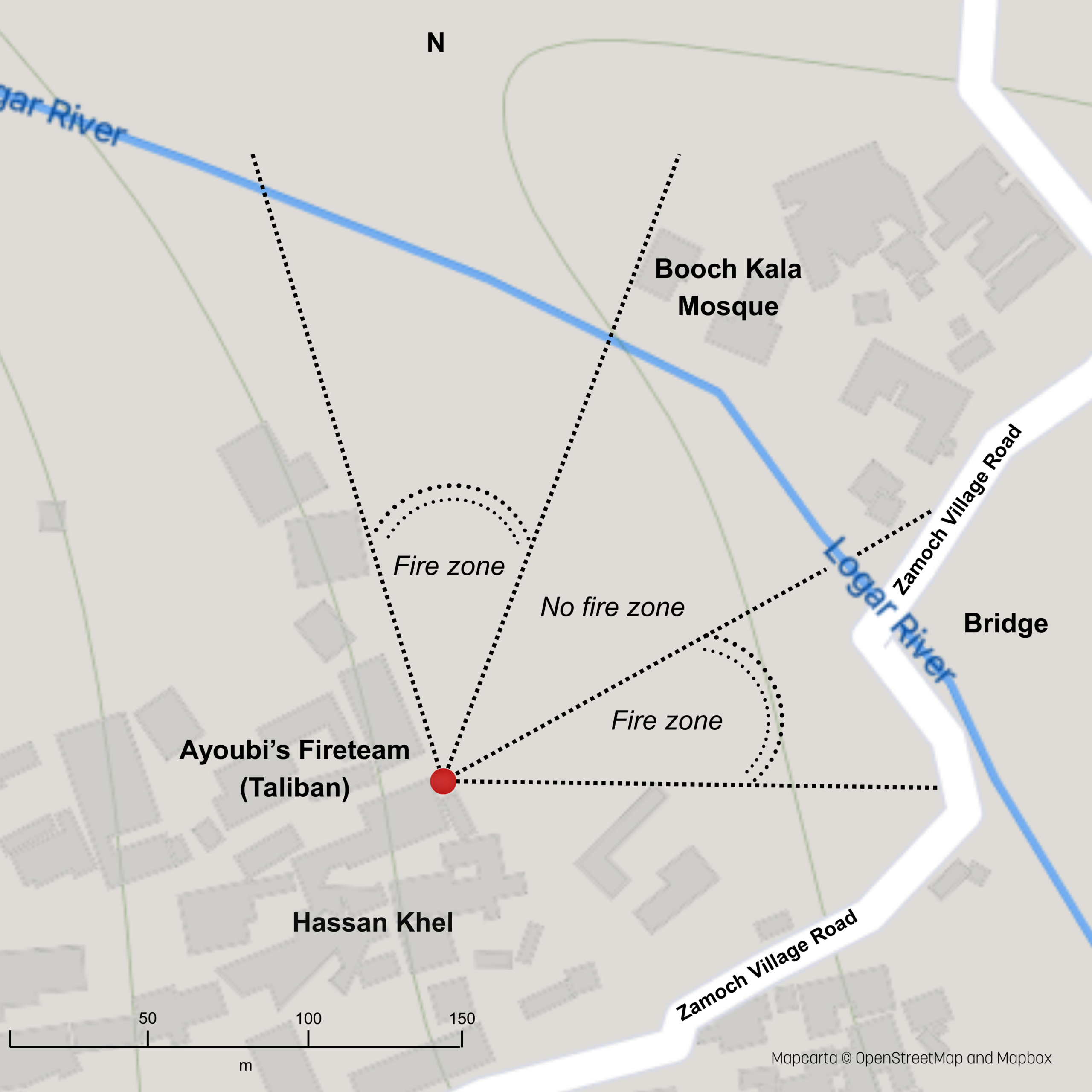
Fig. 2. The Taliban (Ayoubi’s) fireteam and bridge carrying the Zamoch Village Road. Distance from the fire team to the centre of the bridge, and the river, 150m. The mosque and other buildings limit Ayoubi’s zones of fire. Source: Joint Combat Assessment Team (JCAT). Google Maps. Mapcarta © OpenStreetMap and Mapbox [Hi-Res]
The Zamoch Village Road bridge is one of three nearby bridges over the Logar river, and the closest usable bridge to Tahir. Bridges are important in Afghanistan: losing control of one can result in miles of enforced detour, as Tahir is finding out. Of course the Taliban are up on it.
The bridge is held by a Taliban relief force, including a small RPG fire team, situated nearby in a towered mud brick building, or “qalat” (Source: Joint Combat Assessment Team, JCAT).
The fire team is led by Ghulam Hazrat Ayoubi, said by local media to be a man in his early to mid twenties, once a student of the local high school, liked astronomy they say. The question to ask is, why is Ayoubi’s team located where they are, in a qalat 150m west and slightly south of the bridge?
Why were they there?
The position offers a good view over the river valley and this would be instrumental in the shootdown. The view of the bridge is arguably as important. As well as being an ideal place to fire at anything crossing the Zamoch Village Road bridge, their position also controls its approaches. The distance from the fire point to the bridge is around 150m.
This is within the effective range of the OG-7V antipersonnel rounds the team has for their RPG launchers. Close enough to be reasonably accurate, far enough away for the team to safely manoeuvre after the shot. We know from intelligence in the Colt Report that this bridge was repeatedly mined with improvised explosive devices (IEDs): the Taliban understood its importance.
It is probable Ayoubi’s team are there to maintain situational awareness on the bridge and to ambush any American troops who try to cross it. They have VHF radios to report any comings or goings (which was how they were eventually tracked down).
They also likely know there could be incoming aircraft, transports bringing in American troops, but also drones, fire support aircraft, attack helicopters, which is why at 2AM they are staying in cover. The warmth of the summer night and the heat retention of the mud bricks disrupts any thermal signature. The reports mention the mission’s “ISR” surveillance aircraft were focused on the original raid area several kilometres away. The team was very difficult to detect at this point and, in any event, nobody was looking in their direction.
How did they know the helicopter was coming?
A call comes over the radio.
The Colt Report notes that the Taliban had a “warning system” in the valley that reported on the activities of the US-led coalition. We can therefore assume Ayoubi’s team are not alone: there are observers further up the valley. We know these observers existed: the US Army’s Pathfinder unit engaged “forward observers with VHF radios” during the recovery. Extortion 17 would stay behind the ridge line on the Tangi Dara valley specifically to avoid contact with them.
Where might these observers be located at 2.00AM?
Evidence in the Colt Report notes Taliban observers tended to situate themselves on the valley ridge lines, and in villages, where they were often stationed as night watchmen for the local bazaars: markets typically co-located with the area’s mosques and near the main road.
2.5km to the North West, along the Tangi Road, is the next bridge over the river, in the Do Ab (“Two Waters”) area, a river confluence between the Logar and Tangi rivers. It is highly probable the Taliban had an observation point in the area, and if so, the intelligence in the Colt Report would suggest it is likely located between the Do Ab Khel mosque and the bridge. This location appears to have line of sight to Ayoubi’s position overlooking the Zamoch Village Road bridge around 3.5km of winding canyon away: an apparent fluke of geometry.
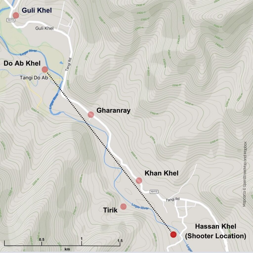
Fig. 3. View of possible and confirmed Taliban positions showing likely control point at the Do Ab river confluence next to the main road, and another likely observation point at Guli Khel. It is 2.5km in a straight line from Do Ab to the Zamoch Village Road Bridge and the Taliban fire team at Hassan Khel. Line of sight shown. Note mountain ridgelines. Mapcarta © OpenStreetMap and Mapbox [Hi-Res]
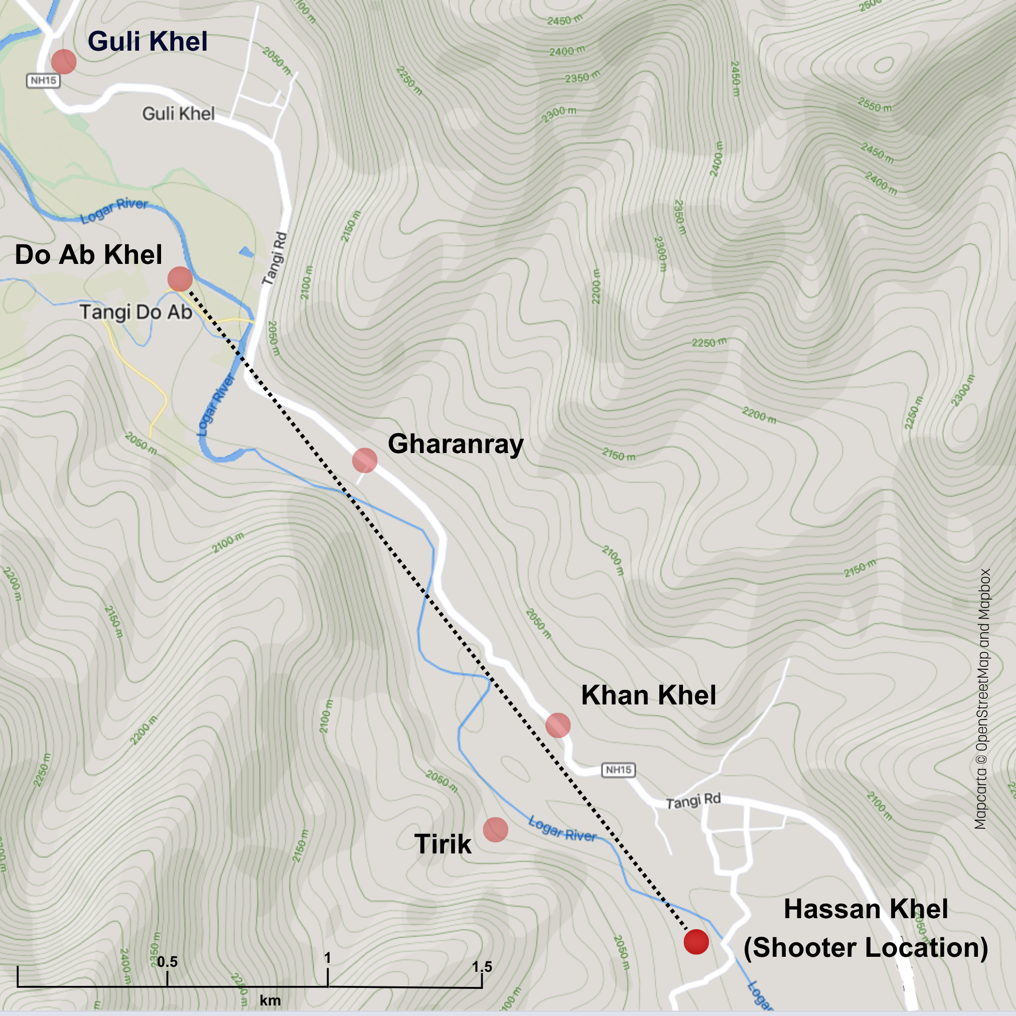
The location at Do Ab also has an apparent line of sight up to buildings on the rising ground overlooking the bridge at Guli Khel, the next bridge up the river, and the last before the Tangi Road leaves the valley and goes over the mountain to join up with the Ghazni-Kabul Highway. The area between the bridge and the Guli Khel mosque, again, probably has an observation point.
It is possible the Do Ab location even once had line of sight to buildings close to the bridge in the village of Spin Wersek in the south of the area, 5.2km away in a straight line, until modern buildings appeared (they obscure the terrain in satellite photos).
Regardless, VHF reception from handheld radios, which benefit from line of sight, would be optimal between all of Guli Khel, Hassan Khel, Do Ab Khel and Spin Wersek – covering over 6km of the valley (7.5km of the winding road or river). The Colt report mentions the Taliban using tracer rounds, visible bullets, fired in the air as signalling devices, which would be a workable line-of-sight warning system across these locations.
The Do Ab location is an obvious control point which means it is likely to be the observer’s regular station and would be immediately reinforced once news of the nearby battle with the Rangers was received. The map shows several ridgelines overlooking the village, the roads and the rivers. If the Taliban has a web of lookouts and armed men in this part of the Tangi Valley, this is the home of the spider.
And Extortion 17 will fly right past it – less than 500m away – the flight plan shows the helicopter passing south of Do Ab Khel village.
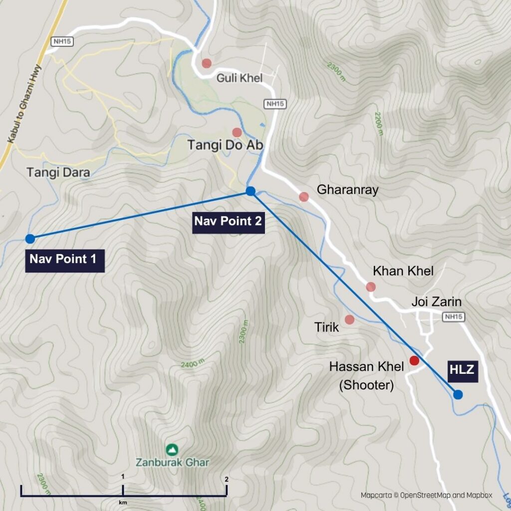
Fig. 4. Map showing Extortion 17 flight plan, given in the Colt Report, in blue, tracking the ridge line south of the Tangi Dara valley before flying past Do Ab into the Logar River valley (the plan route nominally goes through the ridgeline: the helicopter would turn into the valley). Red dots are Taliban positions (possible or confirmed). Distance between the Nav point 1 and 2 is 2.1km Mapcarta © OpenStreetMap and Mapbox. [Hi-Res]

Such alignments might appear coincidental. Should the reader find themselves in the region with the leisure to look around, they would discover forts, towers, and caravanserai, with some sites dating back to the Bronze Age. Thousands of years of conflict.
Roads, bridges and villages are built where they can be defended. Before VHF radios and tracer rounds, signalling was done with beacons, mirrors, lanterns, fireworks and flags. Night watchmen or “Pasban” in Afghan towns have been signalling with lanterns since antiquity. Mosques share the timings of religious fasts using flags to this day: they are built where they can be seen. The Taliban didn’t invent these geometries and techniques: they just used them.
For Ayoubi and his men, the main threat is not the base that the NSWDG troops and their attachments took off from, FOB Shank 30km off to the east. It is the Government troops, police, and American soldiers based in the city of Sayad Abad eight km (5 miles) by road to the west.
These people are the usual banes of Ayoubi’s life. To go further into the valley, they have to pass through the Do Ab area, whether coming from the north, or via the Tangi Dara mountain pass and river valley to the west. Just as empires have for millennia. This back door would not be left open, especially given the firefight to the south earlier that night.
Let us say it plainly: at 2.37AM when Extortion 17 goes through Do Ab – which it must – it is highly probable that there is a Taliban soldier with a VHF radio and a digital watch timing its progress.
The Colt report says observers in the area had been carefully noting the routes taken by US aircraft over the previous few months.
He would know the helicopter has to navigate carefully between the two ridgelines southeast of Do Ab. The valley narrows to some 200m wide at the hamlet of Gharanray, 500 metres away from where Extortion 17 enters the Logar River Valley.
So when the helicopter flies past, we can imagine he will call it in. “Invader helicopter heading your way. Just over a minute, brother.”
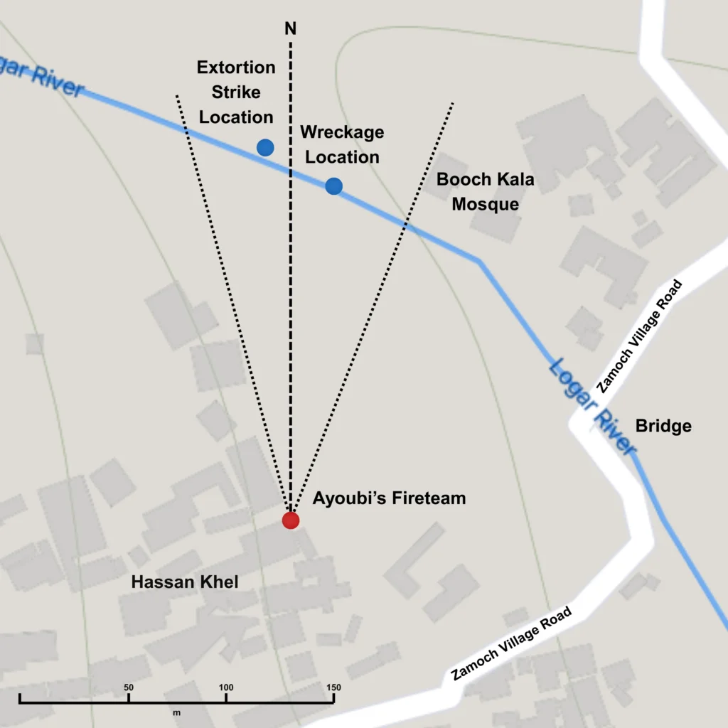
Fig. 5. Map showing shootdown area. Source: JCAT report. Ayoubi’s team has to fire due north, (actual shot was 5 degrees west of due north) to avoid hitting nearby buildings, including the local mosque. Arc limits shown in dotted lines. Distance between Ayoubi and strike is 190m. Mapcarta © OpenStreetMap and Mapbox [Hi-Res]

He would have made similar calls a dozen times before, to warn his comrades about American airpower heading up or down the valley. Normally the Taliban troops hide. Tonight is different.
Ayoubi will hear the call. He is wide awake. Colt says the Taliban in the valley have a high level of readiness, following the Ranger raid.
Radio intercepts reviewed afterwards confirmed Ayoubi was part of a separate team from the Taliban group fleeing the Rangers. His team were not panicked refugees from the raid, firing blind into the night: they were part of a determined and organised relief force.
We can nevertheless assume Ayoubi’s team have probably heard their comrades’ VHF radio calls from the earlier battle with the Rangers 3.5km away. They will likely be aware that many of those comrades are now dead. The local honour code, Pashtunwali, demands vengeance. It also demands they protect their surviving comrades from further American attacks. Ayoubi and his team head to the roof and ready their weapons.
How did they make the shot?
The data JCAT report indicates that the shot was fired ~3 degrees west of due north. Which makes us ask two questions: 1. why fire north, and 2. why not fire exactly north?
Ayoubi was not debriefed by Coalition forces after the shootdown: this is therefore inevitably a process of inference.
The terrain and nearby buildings block the shooters’ aim to the west. They likely want to avoid hitting the mosque to the north east.
So the team chooses a zone fire strategy: they get ready to fire a volley along a single azimuth where they believe the helicopter will eventually be, that will also take any missed shots away from their own people.
The Taliban later released propaganda praising the shooter, mentioning his supposed love for astronomy and knowledge of the stars. To the press (and to the author, for several years), this sounded like poetic fluff: echoes of historical heroes navigating by “stone and stars”.
Read in operational rather than poetic register, it can be taken as a resume. He may not just have watched the stars: he likely used them to control the fire from his team. Given the inaccuracy or “dispersion” of RPG rounds, he would have wanted to stay west of the azimuth pointing due north towards the star, to avoid hitting the Booch Kala mosque to the north east.
The “poetics” also imply familiarity with the use of optics at night.
The helicopter was reported to be “blacked out”, making it hard to see, according to the Apache helicopter pilots operating in the area (who were using advanced, third generation night vision gear). The crew of the AC-130 fire support plane covering the HLZ nevertheless noted the accuracy of all three RPG shots they saw fired, and speculated whether night vision gear was involved. Extortion 16, another Chinook nearby, noted that the attackers appeared to be responding to infrared light being shone on the landing site by the AC-130, the so-called “burn”. The burn was used to mark the landing zone for the incoming helicopter and to detect attackers who might be hiding close by.
With eyes fully adapted to the night, even a faint visual signature is enough through simple binoculars or the sights of an RPG-7 launcher. Obstruction of the star field by the fuselage of the helicopter might well have been sufficient.
Modern military level night vision gear was still very rare for the Taliban at this time. However, cheap night-hunting binoculars using the old Generation 1 technology were available, running to a couple of hundred dollars. Typically these were repurposed observer’s binoculars from the Soviet era (or occasionally consumer gear bought new on shopping trips to Dubai). The Soviet gear is, at the time of writing, still readily available on eBay, and there was a lot already in circulation by 1989 when the Soviets withdrew . The town of Darra Adam Khel in Waziristan, just across the Pakistan border had a small cottage industry refurbishing such devices, allowing them to be run from consumer batteries. As far as the author knows, it still does.
An observer with a pair of these Soviet-era binoculars near Gharanray (2km northwest of the shooters), the village of Khan Khel down the valley (700m northwest of the shooters), or in Joi Zarin, Hassan Khel, or Booch Kala by the Zamoch Village Road bridge could have been able to see the infrared light on the landing zone. The “burn” covered an area the size of a football field. If so, they would have known exactly where the helicopter was heading. The sound of the circling Apache helicopters near the landing zone would also provide some indication: this is noted in the Colt report.
We cannot tell what visibility the Taliban had: it could be that the fire team were shooting entirely into the dark, aiming ahead of the sound of the helicopter. The observers on the scene suggested otherwise. Colt does not rule it out either.
The use of night vision was possible, but probably unnecessary. Acquiring the location of the Chinook as it moved through the valley was likely easily possible through sound. Because it was above the mountain ridgeline from the perspective of the shooters, they could straightforwardly have acquired it visually when it arrived nearby, despite the dark conditions.
From the position, altitude and heading data in the JCAT report, we can calculate that Ayoubi’s team opened fire just as the helicopter cleared the line of buildings to their north, as it came in from the north west. At this point, calculations using the data in the JCAT report indicate that the helicopter would have been silhouetted against the night sky, being at 7-8 degrees above Ayoubi, just above the ridgeline shadow created by the mountains beyond Joi Zarin. The gunner in the helicopter would have had limited or no time to see the RPG shot or fire back before the shooters moved back into cover. It is suggested he nevertheless did fire on the shooters: testimony in the Colt Report says spent casings were found in the wreckage.
We know Ayoubi must have allowed for a drop in elevation of an unguided shot (some 8m at that range using an OG-7V), so he knew how to work the sights on his launcher, which allow for range (vertical) and lead/windage (horizontal). Like a bullet, OG-7V projectiles have no rocket built in, so they fly in an arc.
We also know he fired ahead of the helicopter, and so would probably have been sighted on a terrain feature (such as a high point on the ridge above him): had he fired directly at the helicopter he would have missed. As previously noted, it was reported he went to the nearby High School, so probably knew the landmarks well. Regardless, US-led coalition helicopters had been flying routes through the valley all year, and we know that Casio F-91W watches and similar (which had built in stopwatches accurate to 1/100th of a second) were widely used, to the extent they were called “Taliban specials” by UK troops: we can assume Ayoubi’s team had routes analysed with accurate timings.
Given the time from when the helicopter cleared the obstruction to when he fired, he must already have been set up to make the shot, which means he must have had sufficient warning to prepare ahead of the helicopter’s arrival.
The attack as described here is characteristic of a prepared ambush from a defiladed position using an offset marker, the same strategy the Taliban repeatedly used to ambush road vehicles. Using terrain points to establish a line of aim and prepare an ambush is a standard insurgent tactic.
It need not have taken long to prepare. Hassan Khel, where the shooters were situated, is 20 minutes drive from Sayad Abad, the natural location for the Taliban reinforcements to come from. Do Ab, as noted, is en route from Sayad Abad, 10 minutes away. Other potential observation points: Gharanray, Khan Khel, and Tirik, (opposite Khan Khel in the valley), are either on the way or no more than fifteen minutes away from Hassan Khel on foot. The shootdown took place three hours after the Ranger raid at Kamran Khel: this allowed plenty of set up time for a team familiar with the terrain.
In any event, it is highly probable that when the helicopter ended up in front of Ayoubi’s team, they knew within a small window where it would be and were lined up to take the shot.
The Target: Tahir
Let us go back to Tahir, the target of Extortion’s mission. What is he doing at 2AM?
Tahir is 1.3 km away (under a mile) from the Zamoch Village Road, and from the bridge currently being guarded by Ayoubi’s fire team.
The area containing Ayoubi’s team, Hassan Khel, is residential. It is Afghanistan, 2AM: you do not open the door to random gangsters: Tahir had found himself knocking on many resolutely closed doors earlier that night.
The neighbourhood is likely to be friendly. “Friendly” in this context means weapons, men, food, maybe a vehicle… in other words, relief.
Tahir could head into Hassan Khel and escape through the town of Koz Timurkhel to the south. Alternatively, reinforcements could cross the bridge and escort him into the built up Joi Zarin area to the north.
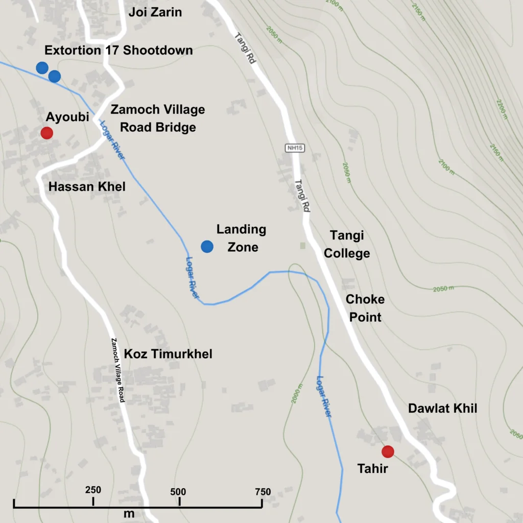
Fig. 6. Tahir’s challenge. Tahir has allies at the Zamoch Village Road bridge, 1.3km away to his northwest. With them, he can then flee to Joi Zarin in the north, or Koz Timurkhel on the road heading south. He is 650m south east of a choke point where the river and road come together. Mapcarta © OpenStreetMap and Mapbox [Hi-Res]

However, if you are Tahir you have a big problem: 650m north west of you, between you and the bridge, the strip of land you are on is about to narrow.
A bend of the river in the West brings it very close to the main road and rising ground to the East. You go on either of these, you die. Either attacked by the Apache helicopters who just killed six of your men during the Ranger raid, or shredded by one of the IEDs your guys have spent the summer planting on that part of the Tangi Road. Or both. It is a classic choke point.
Worse still, much of the area is overlooked by the high ground east of Tangi College, which forms a perfect location for snipers or observers. Throw in the college buildings plus the lines of trees around it to the north, east, and west, and it becomes clear it is not just a choke point: it is a killing ground, and you have to pass through it to get to safety.
It is either that or jump into the river. And get machine gunned in the water.
It is really not Tahir’s night.
He does not like any of these options. He hunkers down in a building in the sleeping village of Dawlat Khil, 650m southeast of the choke point, 1.3km from the Zamoch Village Road bridge, and a world away from where he wants to be.
The Interdiction Force: NSWDG
Now let us turn the tables. You are the NSWDG ground force commander, your mission is to stop Tahir meeting up with any relief force and escaping. After that, you want him dead or captured.
You choose a helicopter landing zone (HLZ) between Tahir and the Zamoch Village Road, 2-300m from the Tangi College choke point, or some 800m north-west of Tahir. We know approximately where the HLZ is: it is shown on the maps in the JCAT and Colt reports.
What you are expecting to do is advance on Tahir’s position and either launch a house raid, or surround it and call out those inside (Colt implies this latter was the plan).
Why take so many people?
The challenge you have is Tahir has got ten guys with him (the range was 8-13). Maybe more are hiding in the orchards.
Suppose you have just the 15 SEALs from NSWDG, and the 2 West Coast SEAL augments to go and get him. Would that be enough?
If Tahir and his men come to you (not likely) the plan would clearly be to lock down the area around the Tangi college choke point, and win the gunfight. In which case, 17 SEALs is all you would need.
But you assume Tahir’s team will instead have barricaded themselves in buildings in Dawlat Khil. You also assume, if so, that there will be IEDs, explosive vests or grenades in the mix: many of the Taliban killed near Kamran Khel were equipped with grenade vests.
Suppose Tahir finds another five or ten guys under a rock (or an apple tree): very possible. A Taliban relief force arrives from further up the valley: highly likely. He decides to fight it out. The SEALs start taking casualties. Troops get busy managing all that: the airspace and airwaves get crowded, and the firepower drops sharply.
In short, with just 17 SEALs, it could get very sketchy.
Additional support greatly strengthens the team:
- EOD Technicians help overcome any IEDs.
- A dog handler helps overcome barricades and finds hidden enemies.
- A Signals Cryptologist gives the team eyes and ears in the electronic world, to spot potential threats and overhear plans. Along with the Tactical Communicator, they can also detect and neutralise radio triggers for IEDs, and stop the Taliban leader calling in help.
- Communications are vital: “no comms, no mission.” A Tactical Communicator provides expert comms troubleshooting and support to the commander, and frees up the SEALs’ “radio guy” (the RTO) to act as a forward observer, as part of the reconnaissance team.
- Pararescueman medics, PJs, provide critical care, stabilising and extracting any wounded: one can act as a JTAC, calling in close air support, freeing up another SEAL shooter;
- A Combat Control Team member, a military air traffic controller, manages the stack of aircraft overhead (and manages the exfiltration of the team and any casualties).
All are skilled infantrymen, more than capable of being on a firing line. Bring them all, and you have a robust and flexible top-tier fighting force.
But that is eight more men. Add the 5 man crew of the helicopter, that is 30 Americans. Who would you want to leave out? Really, nobody. To repeat: Tahir is thought to be the regional boss for the Taliban. He is a piece of work. You need to bring everyone.
If Tahir stays in Dawlat Khil, moving up on his position to raid it will not be trivial, requiring a careful set up to be able to fight off any Taliban relief force while navigating the high ground and any IEDs. Nevertheless the choke point, used from the other side, will then serve to keep the raiding party safe from any force trying to rescue Tahir. It is good, but there are a lot of moving parts. One more problem: sunrise is at 0530, and it will start getting light an hour before then. The team will have a couple of hours to get it done. This cannot be a prolonged siege. Get in, get the bad guy, get out.
People like to talk about the heroism of Special Operations Forces but the work is often about navigating complexity while being pressed for time within the hard physical limits of a kinetic environment. That is exactly the situation here.
This complexity, time pressure, and need for careful control explains the presence of one of the Squadron’s “Head Shed” (command team) on the helicopter: its Master Chief.
Why all in one helicopter?
So you need all 25 guys on the ground, but why all in one helicopter? The risk is Tahir could start moving at any time, moving quickly through the orchards towards the bridge and safety. Time is very short. He is also bringing numbers, and more are likely coming.
You simply cannot risk having half the force getting stuck in a second helicopter that gets waved away the moment an enemy fires a rocket near the HLZ.
This risks mission failure, and could see the team left on the ground being overrun.
A small contingent of Afghan partner force troops is also added to the mission. They are experienced soldiers, and their presence is required by the Afghan government. But they are not Tier 1 operators. It might be easy to say, “then bring them in the second helicopter, if they get waved off, they don’t add much combat power anyway.” But this puts that second helicopter, its crew and passengers at risk and overlooks the fact that the valley isn’t deserted: it is populated.
Feelings are running high – not least after tonight’s Ranger raid – in an area where most households are armed. It is the mission of the interpreter and the Afghan commandos to discourage the local residents from rising up against the Americans, as well as to get intelligence from the area and help control the perimeter. Colt is very clear: the team expected to move away on foot and be extracted the next night; that’s a whole day on the ground. The Afghans come with. With the interpreter that is 8 more men, bringing us to 38 in total.
The decision is taken to send all the American and Afghan troops in a single helicopter. The goal is to get the whole force on the ground and operating as quickly as possible – to “mass” the force – ready to protect itself from any Taliban attack and to get after the target.
When it takes off at 2.22AM, every passenger seat on the helicopter is full, with an additional passenger strapped in on the floor amid the mission equipment.
Let us look at what that will mean for Extortion 17’s flight profile.
The last three minutes
With 5 crew, 33 passengers, the helicopter is carrying 38 men. We know that they were planning to extract the ground team the following night, which means they are bringing sustainment: food, water, batteries, extra ammunition.
The aircraft has a maximum theoretical gross weight of 50,000 lbs.
How does this compare to the actual weight of the Extortion 17?
On the face of it, a CH-47D, operating weight ~26,500 lbs including mounting systems commonly fitted for cargo operations, plus another ~2,000 lbs for the various protection systems needed for Afghanistan (ballistic protection, missile warning/jamming, flares, dust protection systems), carrying 33 combat-equipped passengers and five crew (~11,000 lbs), fuel (~4,000 lbs), and say 1500 lbs of mission equipment (ladders, breaching explosives, additional sustainment) should be fine, running at around 45,000lbs. The Colt Report says as much, Ed Darack in his excellent book on the shootdown says the same.
Why was the helicopter flying predictably?
There is an additional factor to consider. Helicopters struggle when they are “hot, high, and heavy”.
The mission is taking place at an altitude of 6700-7000 feet above sea level, in summer time (the pressure altitude at shootdown was 6605 feet). The temperature that night was recorded at 22 degrees C: this makes the air less dense vs. the reference level, giving a higher effective “density altitude”. The thinner air means the helicopter has to work harder to stay aloft.
At a pressure altitude of 6605 feet and a temperature of 22 Deg C, then according to fig. 7A-5-2 of the CH-47D flight manual, the aircraft has a HOGE (hover outside ground effect) lift capacity of ~48,000 lbs. The capacity is further reduced due to the dust filters needed for Afghanistan. The EAPS (Engine Air Particle Separator) dust protection filters rob the engine of inlet pressure, reducing the available torque, taking the HOGE limit down to an estimated ~47,000 pounds. What is not included here is any assessment for the Infrared Suppression System (IRSS) – designed to hide the effects of hot exhaust gases from gen 1 or better night vision gear – as very little published data is available. The combination of weight, balance issues and effects on the power of the engine due to the IRSS would lower the available lift capacity still further. And the assessment also ignores the fact that engines in real world service never run at 100 percent of their theoretical capacity.
If the actual loading of the aircraft took it past the HOGE limit then the helicopter would crucially have required very careful handling. It would have been flyable safely, as the reports say, but it would not have been able to adjust altitude quickly, bank without losing airspeed, or slow sharply. It would have needed to maintain a broadly constant speed coming into the area, and then progressively decelerate as it drew close to the landing zone. As it is, it has very little spare torque. The author’s most optimistic calculations put it at around 4%, for a conservative weight estimate of 45,000 lbs; more likely, it has no spare power margin. Either way it is close to its limit.
We do not know the actual weight figure for Extortion 17 carrying the Immediate Reaction Force. The figure is not given in the published version of the reports: the unredacted form DD 365-4 giving the loading at takeoff is not available, for example.
Perhaps we can make an assessment based on how the aircraft was flown.
Speed-wise, we know that the helicopter was doing around 57 knots at its last BFT transponder ping, 1.1km from the Landing Zone, 350m from the shoot down. The helicopter was reported at being around 50 knots at the time of the shootdown, 700m from the Landing Zone. This is characteristic of progressive deceleration.
What speed was it doing before that? Disappointingly this, too, is not included in the published reports either.
Let us see what we can do to fill this gap.
According to the flight plan, Extortion 17 came in from the west, tracking south of the ridgeline of the Tangi Dara valley before flying into the Do Ab area and turning south east into the Logar river valley. The only other data point we have is that it could see the “burn”, the infrared illumination of the landing zone, 162 seconds before the shootdown (according to the timeline in the JCAT report). To see the burn coming in from the west (after travelling south tracking the Kabul-Ghazni highway, and turning east just north of Sayad Abad), it would need to be clear of the bulk of the mountain of Zhanbarak Ghar to the south. In this case it would see the burn 4.5-5km of flying away, giving an average speed through to the shootdown point of 55-60 knots.
This is consistent with tracking the Kabul-Ghazni highway at cruising speed (~80 knots); turning and trading airspeed for altitude to head up behind the Tangi-Dara ridgeline, before going at a steady speed of between 55-60 knots along behind the ridgeline; then descending and turning into the Logar River valley, and progressively decelerating from there (down to 50 knots at the shootdown point).
This flight profile reflects a pilot flying a heavily loaded helicopter through a hostile, populated mountain area on night vision goggles. It appears he is trying to both minimize exposure to enemy fire and protect a fragile power margin while also tracking the rivers, ridges, and avoiding terrain hazards (mountains, canyon-sides).
Theoretical limits, calculated from charts, are just that. Actual mountains will have temperature gradients and air pressures that do not match a data point from a weather station in a valley. A flight path can be highly constrained once the geometry of making turns is factored in. For a helicopter running heavy, banking the aircraft increases G-loading beyond the engine’s capacity, forcing the pilot to descend just to maintain rotor speed through the turn. David Carter, who Colt reports as flying the aircraft by this point, was one of the US Army’s most experienced aviators flying into the hottest of hot zones: if he had more options available to him, we can assume he would have used them.
The many constraints meant Extortion 17 was effectively on rails after flying past Do Ab. By the time it came off the ridgeline and lined up with the Helicopter Landing Zone, it likely had no great ability to accelerate or decelerate sharply or make sudden changes in altitude. As we have observed, the speed was therefore pretty constant until it was committed to the final approach, when it began a progressive deceleration.
The likely Taliban observers near Do Ab would therefore have known how long it would take the helicopter to get to the next bridge, the one carrying the Zamoch Village Road.
The unit at that bridge, Ayoubi and his fireteam, were ready and waiting for Extortion 17 to arrive.
The choice
So here we are. The decision the NSWDG ground force commander faced. There are 3 choices.
Option 1. Given that only the CH-47D is available, is operating towards its limits, and there is likely to be ground fire: do you risk the whole force in a single helicopter?
Option 2. Do you reduce the impact of a potential shootdown by splitting the force, at the risk of both failing the mission and seeing the NSWDG SEAL Troop being overrun?
Option 3 is that the ground force commander turns to the mission planner and says something like this:
“OK, let’s look at the map. Tahir is there (points at the village of Dawlat Khil). You want to insert the team here (points at the HLZ). You then either go in and get him; or if he makes a break for it, gun him down here (points at Tangi College).
To make this happen, you want to take a CH-47D, fill it with 25 of our top guys and 8 Afghans. Make that 38 top guys, including the crew.
You can’t run a helicopter up from the south because Tahir might notice a Chinook flying past his house, one might say, and there goes our element of surprise.
So you’ll fly the bird in from the north west. She’s running heavy so you’ll have to keep her on an even keel: fast enough to get past the Taliban, slow enough to avoid the canyon walls. All very Luke Skywalker.
So, track the Kabul-Ghazni Highway until about here, going full tilt. Haul the heavy bird up behind the Tangi Dara ridgeline here. Sneak it along behind the ridgeline, then drop it into the valley not far from the likely Taliban control point at Do Ab. Maybe wave as we go on by.
Stick it through the canyon east and south of Do Ab, while dumping a bit of speed.
Point it at the HLZ, then run it between Joi Zarin to the north and Hassan Khel here to the south, as you slow on the final approach, and hope nobody on any of these roofs has a DShK or an RPG. Which is a bet you know we’re going to lose, thank you again Siraj Haqqani.
Then, after some off-the-charts sketchiness, sigh of relief. The bird hits the HLZ, the boys hop out and get after it. Swift justice is delivered to Tahir. Job done. Back home in time for chow.
OK. Let me tell you something. This guy didn’t panic when the Rangers knocked on his door. He had a plan. He got his gang together and he ran into a fortress. He is relying on his guys to pull up the drawbridge and man the walls. Which I can guarantee you they are doing right now. It’s going to be crawling with Taliban headbangers. They will come with everything they’ve got.
You go in there and one will get you two you’re not coming out. Their house, their rules.
I’m not placing that bet. You don’t have a mission. It’s scrubbed. The Rangers let him get away this time. It’s a shame. Get him next time.
Short of getting the Rangers’ 11 Charlies to drop a few rounds on that roof, in the hope he comes out with his hands up, we’ve got nothing.”
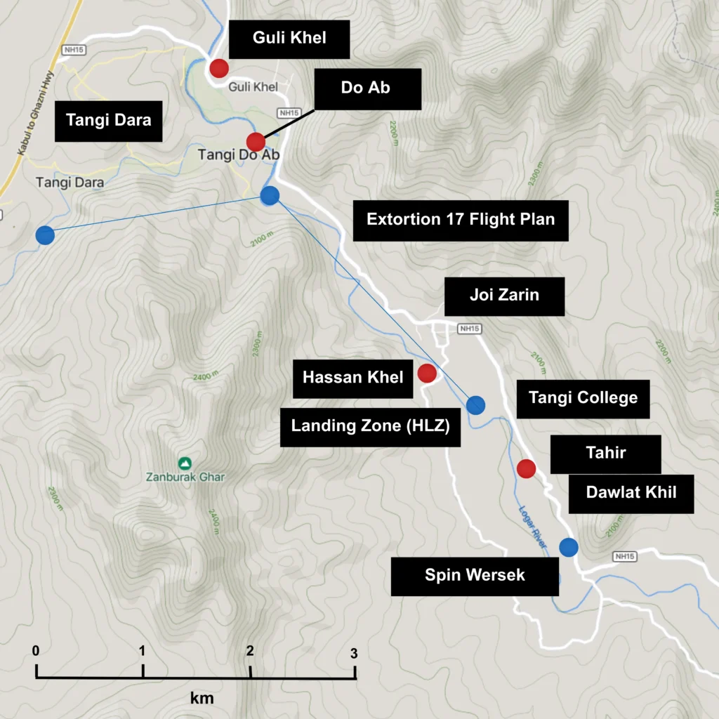
Fig. 7. Ground Force Commander’s Map: Walkthrough of Option 3. Mapcarta © OpenStreetMap and Mapbox [Hi-Res]

For the reader looking for a single-paragraph explanation of the shootdown, this is it: you are flying into a heavily defended area with really constrained flight approaches. Because it is so heavily defended, you cannot win. If you go in light, you risk being overrun. If you go in heavy, you risk the helicopter being shot down. If you scrub the mission, the bad guy gets away. To quote the computer in the film War Games, “A strange game. The only winning move is not to play.”
For the account given here to be true, it only requires you to support two logical inferences, namely:
i) The Taliban had observers further up the valley, who warned Ayoubi’s fire team posted by the Zamoch Village Road bridge of the incoming helicopter. We know these observers existed.
ii) The NSWDG SEALs brought additional troops and placed them all in one helicopter to improve the chance of mission success and to avoid being overrun by the Taliban. We know who was on the helicopter.
Both of these would be in line with standard military doctrine and the evidence in the Colt and JCAT reports. Everything else is a function of the terrain, the weather, the known positions of the combatants, and the equipment available.
These are the calculations of war. We have reconstructed them here from published reports and logical deductions, and with the luxury of time and distance.
The ground force commander had three options that night. He made his decision.
The Strike: Extortion 17 Shot Down
On August 6th, 2011 at approx 0239, a US Army CH-47D Chinook, call-sign “Extortion 17″ arrived in the valley area approx. 240m to the north west of the Zamoch Village Road Bridge over the Logar River. It was en route to a landing zone approx 800m to the south east. On board were 5 crew and 33 passengers, and a dog being held in his handler’s arms.
The helicopter was attacked by a unit of the Taliban, from an elevated position approx. 150m west and slightly south of the bridge. The Taliban unit fired a volley of at least two rocket propelled grenades just west of due north (~357 degrees).
One of these, later confirmed as an OG-7V munition, travelled approx. 190m and struck one of the blades of the helicopter’s rear rotor assembly. It detonated, shearing off a 3m length of the blade, and generating a bloom of shrapnel.
The damaged rotor became violently unbalanced. The resulting vibration ripped the rear pylon from the fuselage, sending the aircraft into an uncontrollable flat spin. The aircraft began to disintegrate, falling into the valley, where it exploded. There could be no survivors.
Those on board included some of the finest human beings in the world.
They are missed to this day.
Strategic Context – “An end to War”
The Weapon(s)
The OG-7V rocket that destroyed Extortion 17 was likely made by VMZ, the Bulgarian nationalised arms company, then a primary supplier of such ammunition to the Afghan National Army; typically it was contracted for this supply by the US Government through a third party intermediary. The JCAT test was with a “Bulgarian” OG-7V, and while other countries make OG-7 variants, the Bulgarian version has been iteratively developed such that it is significantly different. Modernised versions put out twice the bloom of shrapnel, for example.
The match to the JCAT test was so close that the author considers it highly probable: for practical purposes, it is as close to certain as the available evidence allows. For those with an interest, the most likely round would be the OG-7VMZ, a 2005-2010 era variant, made in the factory in Sopot, in the Rozova Dolina region. A photograph of one of these appears in the JCAT report. The explosive power, fuze sensitivity and accuracy matches the profile of the weapon used in the shootdown.
By this point in the war newly produced ammunition was flooding into the country, thanks to the American funding: the weapon had been shipped to the Afghan Army and then stolen, most likely, but it may have been part of an international shipment diverted via Pakistan and smuggled by the Haqqanis. Either way, it was the latest equipment: highly desirable. The Haqqanis provided experts to train and mentor IEA troops in the use of weaponry: was Ayoubi one of these? We do not know, but he did demonstrate a high level of proficiency.
It was just one weapon, worth a few hundred dollars, out of billions of dollars worth of arms shipments to Afghanistan. All made by manufacturers who profited handsomely from the conflict. The Rozova Dolina region where the rocket was likely made is said to be enjoying “a new golden age” due to the money made by arms factories in the area, but these days it is from the profits of the conflicts in Ukraine, Sudan and DRC.
Spinning the wheel: Tempo and Probability
The Tangi Valley shootdown did not occur in isolation. The rocket that destroyed Extortion 17 was fired as part of the third RPG attack on coalition helicopters during two months in that part of the valley.
The Spin Wersek area, the same place where the Rangers broke off the pursuit of Tahir, had seen an attack on 6th Jun 2011, exactly two months before. According to data in the JCAT report, 14 RPGs were fired from 5-6 points of origin at a US CH-47D Chinook. The location is ~2.5km south of the Extortion 17 shootdown point.
Just over a fortnight before Extortion 17, on 21 July 2011, a Nightstalker MH-47G Chinook was attacked by 1+ RPGs near Khan Khel. This location is on the approach vector for Extortion 17, about ~700m northwest of the Extortion 17 strike location.
During this period, JSOC was responsible for as many as 10 high risk missions per night across Afghanistan, almost all based on helicopter insertions (it may have been higher in peak periods: the Open Society report in the references, released a few weeks after the shootdown, records more than 20 raids per night in Afghanistan, the “vast majority” conducted by JSOC).
Some years ago, the author spoke to a croupier who worked roulette at high-end parties. He said he could empty the pockets of a room in ninety minutes. When asked how, he answered as follows: “In double-zero roulette,” he said, “the odds are roughly 5 percent in favor of the house. The faster you spin the wheel, the more times the house wins, and the sooner you get all the cash.”
Every helicopter mission in Afghanistan was a spin of the wheel. Planning, pilot skill, and thermal sensors could stack the odds, but they could not eliminate the House Edge held by the Taliban. And in 2011, JSOC was spinning that wheel ten or more times a night. Sooner or later, the ball would land on Zero.
In the early hours of August 6th, 2011, in the Tangi Valley, it finally did.
The Islamic Emirate of Afghanistan
After their August 2021 victory, the Taliban and Haqqanis run the new Islamic Emirate government. The human rights situation in Afghanistan, especially for women, is consequently very poor. The economy is not doing well, not helped by continuing armed conflict with neighbouring Pakistan. The leaders of the two groups are nevertheless poised to make huge sums from Afghanistan’s enormous mineral wealth. The one-time operatives enjoy lives of comparative ease, which includes luxury cars, fine dining, and taking shopping holidays in Dubai.
Ayoubi, the Taliban shooter team leader, and Qari Tahir, the original target of the Ranger raid are not among them – they were killed by the Americans within a month of the shootdown.
Ayoubi had made the fatal mistake of claiming credit for the shootdown over VHF radio. The Americans were listening. He and his fire team were located and bombed.
Tahir had been spotted traversing a dry river bed – often used for back country navigation in the area during summer. Coalition forces promptly targeted him with an air strike.
Another commander would soon rise to take his place. Following the events of 2011, the Tangi Valley fell firmly under Taliban control, and would remain so until the end of the war.
Next, go forward to Part 3. – Reflections to consider the human cost, and learn about the lasting impact of the shootdown.
Go to the Data page to obtain the key data supporting this narrative.
Go to Downloads to get a full copy of this report, access the source materials and download a JSON file with the battlefield data.
Go to Support Resources to get access to 24/7 wide eligibility support.
Or, go back to Part 1. – The Friendship to find out about some of the men onboard and the “curious friendship”.